Brixton: a short history |
The London district of Brixton lies to the south of the River Thames,
near the district of Dulwich and has a unique history, stretching back a
thousand years.. The earliest surviving traces of human activity
in the area are the lines of two Roman roads, Clapham Road (A3) and
Brixton Rd (A23), with the A3 being the more important, linking the City
of London with the port of Chichester.
In the 11th century the area was known as Brixistane which means 'the
stone of Brihtsige'. These stones were used as a meeting point for
communities. Over the years this became shortened to
Brixton. Up until the Industrial Revolution and the coming of the
railways, Brixton remained undeveloped and mainly agricultural. |
|
On the left:
Tenpenny's Farm, Coldharbour Lane, Brixton End
Coldharbour Lane cottage (date unknown)
|
The first speculative development started after the construction of the
Vauxhall Bridge in 1816, with 'ribbon' development occurring around Acre
Lane (the oldest buildings in Brixton include
St
Matthews Church, 1812, 46 Acre Lane 1808 and the
Trinity
Almshouses, Acre Lane, 1824). |
The small settlement underwent a huge transformation between the 1860s
and 1890s, as railways and trams linked Brixton with the centre of
London. In 1880,
Electric
Avenue was so named after it became the first street in the area to
be lit by electricity (Eddy Grant sang about it nearly 100 years later).
Large, expensive houses were constructed along the main trunk routes
into Brixton, attracting the middle classes. At the turn of the century
the area underwent a great social upheaval as the middle classes moved
out to be replaced by a huge working class population.
»
Map of Brixton area, 1870
»
Booth's Map of Brixton area, 1898-99 |
Many of the big houses were converted into flats or boarding houses
which proved very popular with theatre people working in the West End
theatres, marking the start of Brixton's close association with the
arts.
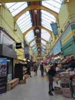
By 1925, Brixton had the largest and best shopping centre in south
London with
department stores, a thriving
market,
cinemas,
pubs
and a
theatre attracting thousands to the area. |
Post war decline
The area was bombed substantially during WW2, leading to a severe
housing crisis, exacerbated by the decline in privately rented
accommodation that had begun after the introduction of rent controls
during the First World War.
Knackered privately rented houses were often sold to cash-strapped
occupiers, while some houses on the end of their leases were left to
quietly fall about as landlords tried to squeeze the last few bob out of
the property.
With many houses in appalling disrepair, slum clearances followed with
Council housing filling the gaps, leading to a demographic shift in the
area. |
In the 1940s and 1950s many of the immigrants who came to Britain from
the West Indies settled in Brixton and have continued to contribute to
its electric, eclectic, multi-cultural feel ever since. (See the BBC's
Windrush feature).
It has been rumoured that Brixton was chosen as a destination for
immigrants as many of the first wave were initially housed in temporary
lodgings in a large underground bunker at Stockwell. |
Of course it hasn't all been plain sailing: Brixton has suffered
two major
riots in recent history and remains bedevilled with drug problems.
Some feel that the recent long overdue investment has proved a bit of a
double edged sword, with the slew of swanky bars and restaurants
threatening the very essence of Brixton.
We tend not to agree: it'll take a lot more than a few sushi bars to
kill off the colourful, exciting and unique character of Brixton.
For more info, check out the horribly designed, but well-researched
Brixton Heritage Trails website and the even clunkier (and painfully
creaky) Flash 'enhanced' multimedia nightmare that is the
Archive and Museum of
Black Heritage.
The Lambeth Archives at 52 Knatchbull Road, SE5 (tel: 020 7926 6076)
offers a huge range of archive local material, with old maps, parish
records, photos and a cuttings and ephemera collection
Brixton facts
Between 1910-1938, a greyhound racing track operated in Brixton Rd, on
the current site of St Helen's school (opposite the Max Roach Park).
When the Brixton Astoria opened (now known as the Brixton Academy) it
was billed as 'Brixton's Wonder Picture Theatre'.
The Fridge nightclub was built in 1914 and originally called the
Palladium Cinema.
Between 1910-15, at least 9 cinemas opened in the Brixton area. Some of
the cinemas were situated in railway arches and were later closed on
safety grounds. The Ritzy is the sole survivor. |
|
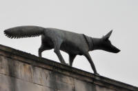
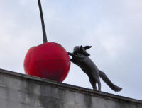
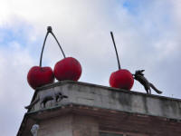
Unveiled in 2010, the Foxes and Cherries sculptures were
created by Buckinghamshire-born artist
Lucy
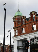
Casson and can be found above Brixton market on the south-west
corner of Electric Avenue and Electric Lane. A graduate of
nearby Camberwell School of Art and a local resident, Casson created
the public art display in the heart of Brixton Market,
partly using recycled materials. Lucy says “Electric Avenue
is the perfect place for these foxes to scavenge cherries from the
market. I like the way foxes live among us; they are part of the layers
of London.” |